
Public Transport
Introduction
Kesgrave is well served by public transport options. It is covered by a number of bus services, community transport options and has great cycle routes. National Coach and Train services can be accessed via Ipswich within 20-30 mins. A number of Taxi companies also cover Kesgrave.
Buses including Martlesham Park & Ride
Map
Key:
- Light Blue 66, Purple 63 and 65,
- Light Green - 64,
- Orange - Park and Ride Route 800, Orange Triangle - Route 800 stop.
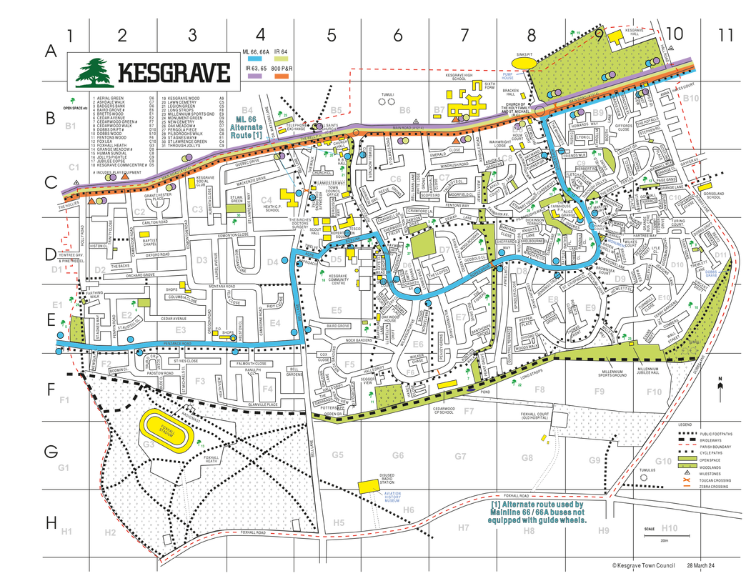
A map showing bus stops and bus routes serving Kesgrave, along with a downloadable version, can be found at:
Timetables
Timetables can be viewed and downloaded at:
 Suffolk onboard bus timetables (all timetables)
- First Bus timetables and routes (Ipswich Park and Ride and Ipswich Reds)
- Ipswich Buses Services nearby (Rushmere / Hospital)
You can also get this information when you’re at a bus stop.
Each bus stop flag has a bus stop code and a telephone number to use. You’ll be sent a message in return with the time of the next bus.
Live Bus Times
Live bus times can be found here:
- Suffolk Onboard live departure board - browser
or you can download the UK Bus Checker Phone App and install it and search/find the bus stop you are interested in or find your nearest one. You can then obtain bus times and/or real time information if it is available.
Alternatively you can monitor bus location via online tracking sites:
Phone Apps and Payment
The following phone apps are available from the bus companies that allow you to buy tickets, view timetables etc:
The following payment options are accepted:
- Phone app
- Contactless
- Apple Pay
- Google Pay
- Cash (exact fare)
Timetable Changes
Bus timetable updates can be found here:
Services
Listed below are the bus services available in Kesgrave along with others nearby (No 4 Bixley - Ipswich, No 73/74 Woodbridge - Martlesham - Felixstowe).
Ipswich Railway Station - Ipswich Dogs Head Street/Revolution – Kesgrave - Martlesham Tesco - Gloster Road
Ipswich Railway Station - Ipswich Dogs Head Street/Revolution – Kesgrave - Martlesham Gloster Road - Eagle Way. (Only 1 bus per hour goes to Eagle Way and it runs here instead of going to Martlesham Tesco)
Old Cattle Market Bus Station – Kesgrave (Main Road) – Martlesham Tesco - Woodbridge – Wickham Market – Framlingham Thomas Mills School
Ipswich Old Cattle Market Bus Station – Kesgrave (Main Road) – A12 - Woodbridge – Melton – Ufford -Wickham Market – Farnham – Saxmundham - Leiston - Aldeburgh
Ipswich Old Cattle Market Bus Station – Kesgrave (Main Road) – Martlesham Tesco - Woodbridge – Melton – some services to Rendlesham
Martlesham P&R Site - High School - Kesgrave Fisheries - Ips Hospital (Woodbridge Road) - Various stops in Ipswich town centre inc close to the Railway Station - Suffolk One (Term Time) - London Road P&R Site

Woodbridge Turban Centre - Martlesham Tesco/BT/Adastral Park - Brightwell - Bucklesham - Kirton - Trimley - Walton - Felixstowe. 74 - Starts at Kesgrave High School (one per day)
Contact details, timetables, maps, help and support etc for Ipswich Buses and First Bus etc. Also details of how to report Suffolk County Council sponsored services.
Taxis
Coaches
The National Express Network in Ipswich is at Cardinal Park and the direct route takes you to Colchester, Marks Tey, Braintree, Stansted Airport, Heathrow Airport Terminal 2, London Victoria and London Stratford.
Trains
The station serves the main line from Norwich to London Liverpool Street, and branch lines to Felixstowe, Cambridge/Peterborough and Lowestoft.
Journey Planning
Useful resources for planning travel by bus, train, coach and ferry throughout Norfolk, Suffolk and Cambridgeshire, nationally and internationally by train and coach.